With a new airplane, and a summer of no school for the kids and no full-time work for myself and Linda, we decided to try to embark on a long, literal cross-country trip to visit Linda’s relatives in Toronto.
There are so many factors for this. With some (written and verbal) help from Colin, I planned out some of the key steps of preparation. First, I made sure the airplane was current on inspections, and that things that weren’t working as well as I wanted were nice and happy. This meant getting a 50-hr PowerFlow exhaust check done, and a 100hr fuel injector line inspection, and making sure my oil was reasonably recent, and solving a problem with a hotter-than-others cylinder. Eventually, I felt ready mechanically.
 Second, I needed a route. To cross the Rockies, I decided on a flight through Lake Havasu (KHII), which I was familiar with from the Prescott flight a few years ago. Then we’d go to Albuquerque where we have friends who could host us for the night (and give the kids a few friends to play with). Then, we’d try to fly northeast and try to get to Chicago, where we might be able to spend an extra day or two and take kids to various museums etc. And then we’d cross over the border to Canada and fly to Toronto.
With a rough route in mind, the next step was preparing for the border crossing. Following a nice guide from AOPA, I just had to go through a series of steps and make sure that everything came together on time. This meant getting my permanent registration papers (which barely came on time), getting the FCC radio paperwork (supposed to take weeks, but actually took two days and was delivered electronically), getting the DHS decal (came maybe two days before departure), making sure the insurance was correct (it was in my name, while I actually registered the plane in the name of an LLC), signing up for eAPIS and ensuring our passports were current, getting my drivers license renewed (also barely done on time), and a few odds and ends.
Then came the weight & balance worries. My plane has a pretty low useful load and poor balance — one advantage of a late-2007 Diamond Star is that 50-gallon tanks came standard and you can fly longer legs, but it comes at a cost of W&B issues when the airplane has more than two people in it. The useful load is 835 lbs, and with 50 gal of avgas that leaves me so little weight that with two adults and two kids we’re actually overweight. If we fly with 40 gallons instead of 50, we are underweight and can bring some baggage, but again have to watch what we take and where we put it (plus we have to constantly deal with getting under 40 gallons in the tank). In the end, we were limited to 45 lbs of baggage, and that included airplane equipment like tie-downs and spare oil etc. Plus, my dad insisted that if I take my wife and kids, we must bring a bunch of spare water in case we have to land in the desert somewhere. So, in the end, we fit, but at the cost of going down to about 4 days of clothing, and not being able to bring books (though Kindles are magic).
In the last few days before departure, a new problem arose. The day before we intended to depart was the first day of a gigantic heat wave that was hitting southwest of the US, and one effect of this was that Lake Havasu was going to be 49º C during the day, and basically above 40º all day after 9am. I didn’t want to put either my airplane nor my passengers through a landing, taxi, and departure in that heat. So instead we decided to make our first stop in Flagstaff, AZ, assuming that noontime thunderstorms were not going to be a problem.
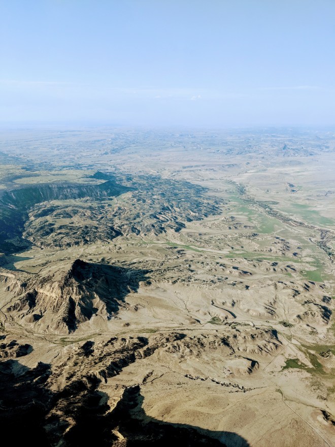
First Leg, Day 1: KSMO to KFLG
 We departed on Wednesday morning, running about 90 minutes behind schedule. This was Linda’s first long flight with me (and the first flight in the new airplane), and Roan’s second flight with me (and also the first in the new airplane). Departing from Santa Monica was pretty easy, despite a few clouds in the area, and we proceeded through the Banning pass climbing up to 9,500 ft, and then proceeded direct to overfly Lake Havasu. That’s when we ran into some turbulence, and some scattered precipitation. I have two sources of in-flight weather: ADS-B In (from a Stratux), and XM Weather. These two were actually decently useful at providing an up-to-date picture of what was going on ahead of me, and — combining it with what was visible out of the window — made it possible to scoot

around clouds giving them enough room when need be. The hills provided some bumps at first, and often made it hard to keep altitude: the autopilot would attempt to maintain a certain altitude, but I suspect that the hills and weather caused pockets of different pressure that constantly drove the indicated altitude up or down. The autopilot would then try to adjust, either trying to climb at some slow speed, or speeding up on the way down to altitude.
At times, I’ve had to switch into pitch mode so that the autopilot wouldn’t try to get me close to stall speed.

Landing at Flagstaff was reasonably easy, though it’s a high density airport and I had to plan for a faster-than-usual sink rate and a longer-than-usual rollout. We parked at the Wiseman FBO, where they were super-awesome, let us play with their FBO cat (named Cessna), and gave us a crew car that we took to town to get lunch.
Second Leg, Day 1: KFLG to KABQ
Getting out of Flagstaff proved to be a bit challenging. First, weather in the form of precipitation and thunderstorms was coming in from the west — and we were trying to get out and continue east.

When we got back to the FBO, we had to scoot pretty quickly and figure out how to depart the area given the thunderstorms that we could see on radar — it was far enough away to not affect the airport yet, but I didn’t want to get trapped by a system that was going to move in for many hours. Flagstaff is a high-altitude airport, and the plane was fully loaded, and it was surprising how poorly the airplane climbed — during the takeoff roll I had to make a decision whether to actually reduce mixture from where I had it set, or to abort the takeoff. With a lot of runway in front of me, I found a position that generated more power and we lifted off, but still climbed pretty sluggishly for the next five minutes. I have taken off at altitude in the past, and I knew to expect poor performance and the need to adjust the mixture, but I’d moved it since runup and thus wasn’t in the best-power setting when I started my roll. Lesson learned.

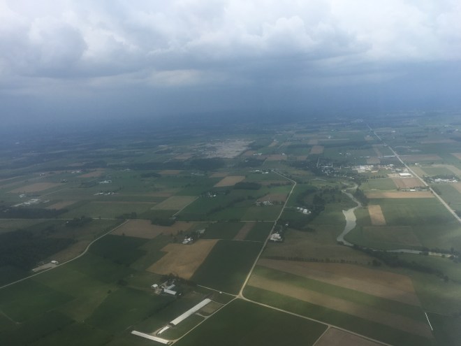
This leg took us over even less hospitable terrain with more bumps. We climbed to 11,500 ft for a time to keep well above the cloud layer, and that helped with the turbulence a bit too. Both the kids were deep in reading or watching some movie on the computer in the back, so this was not so much because they were complaining but because I didn’t want a repeat of the first leg where we had to work hard to keep altitude.
Landing at Albuquerque was straightforward and this time I was better prepared for higher-altitude performance; we parked at Cutter and left the airplane for the night. Time to go visit our friends and spend the night in Albuquerque. Which we did, watching the lightning and listening to the thunder of the storms passing overhead.

Third Leg, Day 2: KABQ to KAMA
 Our intent the next morning was to a) leave early enough that the thunderstorms don’t start developing yet, and b) go to Liberal, KS, which was on the way. The first part was fine — we got up early and got to the airport. The second part turned out harder: first, our airplane wasn’t ready (the FBO had to pull it out of some hangar or tie-down spot), and second, Liberal wasn’t a good place to go. My instinct told me it was iffy, and so I called a briefer (usually I brief on the iPad) — with the briefer explicitly not recommending VFR flight to Liberal due to radar echoes and low ceilings, I decided we would go further south to Amarillo, TX instead. If the weather there was also not great, we would find yet another place to head to further south still. The ceilings were not that low and were not forecast to be low in enough places within our non-reserve range, and so I felt this was a reasonable plan.
 Amarillo (which for some reason is pronounced with “L” sounds and not “Y” sounds) is in the Texas Panhandle, and is basically directly east of Albuquerque. We climbed to 11,500 ft and cruised over to Amarillo without any problems. Amarillo was impressive in that it was an airport seemingly in the middle of nowhere, and yet there was so much traffic reported by the tower that we were sent on a very long downwind and then asked to do a 360 for spacing. Right above the airport was the meeting point of a bunch of Victor airways — 10 radials of the on-field VOR are used as airways — and so there was high altitude jet traffic as well as low-level airport traffic. The airport was also a hub for military airplanes: we parked at TAC Air and had lunch at the on-field restaurant, but in the meanwhile the FBO was refueling a fighter jet. Pretty awesome.
Fourth Leg, Day 2: KAMA to KICT
 Liberal was still not a good choice, but we were far enough east that we could head northeast without running into the weather. I was originally hoping to get to Kansas City that day, but my fallback was Wichita and so that’s where we headed due to distance and time considerations: I didn’t want to have a 3-hour flight where a 2-hour one would suffice. We climbed to 9,500, but then realized that the cloud layer was in the way — and so both went around and decided to go under it, since ceilings for the rest of our path looked to stay high enough. We eventually dropped down to 5,500 ft, and then even to 4,000 ft (which was less than 3,000 above ground) to avoid clouds.
 Wichita was a pleasure to arrive in — the land below turned green and lush, and it was becoming evening-time. However, there was a nasty cross-wind and we landed a bit rougher than I had wanted (nothing that my passengers noticed, apparently, but enough that I was unhappy). Another thing that was unhappy was my fuel pressure gauge, which took the opportunity of the landing rollout to start going haywire: showing zero, max, correct readings, and alternating between different ones multiple times per second. This was accompanied by audible ding-dongs from the G1000 system. We were on the ground, though, so I taxied to the FBO — Yingling Aviation — and shut down.
After getting our stuff out of the airplane, and refueling, I started troubleshooting the issue. Was this a fuel leak? No, cause nothing was leaking out. Was I actually experiencing fuel pressure issues? Was there vapor in the lines? I started the engine and ran it through different mixture settings, different RPMs, with and without a fuel pump, etc — the gauge kept jumping when the engine was on (but not during priming with the engine off). A mystery.

Fortunately, Yingling has a maintenance shop. And the city is one where not only are Cessnas, Beechcraft, and other airplanes are made, but also Textron and Garmin offices were local. The maintenance shop was open, and a very helpful guy sat down with me for a bit to take a look at the problem. We looked at the maintenance manual for the G1000 and found the part number for the fuel pressure sending unit — which happened to be made by a Wichita company — and he promised to look at it over the rest of the evening. By then my family already took a shuttle to the hotel, and I joined them soon after by Uber. The plane would sit in a hangar being looked at. So, four legs in, I had a maintenance issue which could ground us.
Fifth Leg, Day 3: KICT to KSUS
 After some back and forth, the Yingling folks have taken off the fuel pressure transducer, cleaned the contacts, and started the engine to see everything working well. So, we decided to call the problem done. We spent the evening walking around Wichita’s river bank, looking at the Keeper of the Plains, and then in the morning headed back to the airport.
We decided to go land at the Spirit of St. Loiuis airport — it’s on the outskirts of St. Louis, but convenient with a good FBO (Aero Charter). The flight was a bit more eventful, as we had to deal with clouds at our altitude and had to climb to 9,500ft for a good chunk of the trip. We flew over the beautiful Ozark lakes, and the terrain got greener and more lush. St. Louis was reporting a broken cloud layer, so we descended through the plentiful holes and landed after a few turns in the pattern over the winding Missouri river.


While this was just a fuel stop, we were hungry, and borrowed a crew car from the FBO. After getting food very quickly, we decided to go check out the Gateway Arch in downtown St. Louis, and so ended up with a 30 min trip each way and an a half an hour walk around the Arch area. Time well spent, as the arch and the general area on the bank of the Mississippi was both well maintained, pretty, and worth seeing.
Sixth Leg, Day 3: KSUS to KGYY
 After getting our fill of St. Louis, we climbed back aboard for another two-hour hop to Chicago. Initially, I wanted to end up at the DuPage Airport near Chicago, though from past experience this is actually not a convenient place to downtown and would have required a pricey Uber ride. On the other hand, the airport in Gary, Indiana, was billing itself as the “Gary/Chicago” airport and boasted a 30 minute distance from downtown. There was also a threat of some weather around the city, so we aimed at Gary.
 Immediately after takeoff, the fuel pressure problem started again. Though distracting on takeoff, I quickly analyzed it again to not be a real fuel pressure problem, and decided to continue on to our destination — choosing an FBO at Gary that advertised maintenance services. The flight was smooth, though the incessant beeping from the fuel pressure alarm was incredibly annoying. I ended up keeping either myself, or myself and Linda, isolated from the kids so that they could watch movies or read in peace while we (or I) dealt with the beeps.
 We arrived at Gary shortly after sunset — this was my only evening landing, as it happened. There was absolutely no wind, and I made perhaps the smoothest approach of the trip.
The FBO had two surprises for us, however. First, it turned out that their maintenance folks were closed for the day — and weren’t going to be around during the next two days which were the weekend. Second, the airport was more like an hour away from downtown Chicago by Uber. We booked a hotel and climbed into an Uber, and only made it to Chicago after 10pm — and between hotel check-in and dinner with the kids, we only managed to go to bed after 11:30pm.

The next day was spent exploring Chicago. We went to the Museum of Science and Industry, and the Shedd Aquarium, and had deep dish pizza, and walked around a bit. We decided to try to go to the Field Museum on the following day, a Sunday.
Seventh Leg, Day 4: KGYY to CYZR
But on Sunday, we didn’t go to the Field Museum. There was a threat of impending poor weather later in the day, and we wanted to get to Canada before Linda’s relatives started flying back to their homes, so we decided on a Sunday morning departure.
Once again, we took an hour-long Uber ride to Gary, and then I had to figure out all the details of actually setting us up for crossing the border.

Crossing the border is a tricky affair. Three things had to happen: 1) I needed to be on a flight plan, which meant that I needed to file my departure time and ETA; 2) I needed to file my departure plan in eAPIS, including my departure time and location, arrival time and location, and estimated time when I’d be crossing the border; 3) I had to call up Canadian border patrol and let them know when to expect us. Given that all of these needed time information, I gave them a generous padding for departure — and yet, it took almost thirty minutes of hold time with Canada before I got through to a human, which delayed my departure and made me incorrect on at least some forms I’d filed.
Canadian folks asked fairly basic questions about the aircraft, and then wanted our passport information. They then said to call them once I landed in Canada, and we rushed to take off before our due time expired.
Apart from the incessant bong-bong-bong from the fuel pressure alarm, the flight was uneventful. We followed the south coast of Lake Michigan, and then cut over all of Michigan to the point where Lake Huron starts flowing south towards Lake Erie — and that’s where we crossed the border. Detroit Center had us switch to Canadian ATC (Toronto Center, I think), who promptly had us switch to the advisory frequency for Sarnia Airport. I self-announced and we landed in our first un-towered landing of the trip.

Some new discoveries along the way. First, I didn’t load Canadian airport database into the G1000, which meant that the plane had no idea where Sarnia Airport was. Fortunately it was right next to the border and quite visible from the air, but it was a bit unnerving. Second, because the G1000 had no idea an airport existed at a particular location, the device started freaking out as I descended — my synthetic vision system started turning the screen yellow and then red, and warning about terrain first via visual notes and then by having a voice say “terrain, terrain”. I warned Linda and the kids as soon as I realized this was about to happen, but it was still a bit unnerving for them.
I had two choices for navigation (other than using paper charts, which I had at hand too). I could have reloaded the Garmin databases. This was going to be troublesome since it wasn’t clear to me that I could switch between US-only and all-of-North-America options at will. It seemed like I could only make the choice when subscribing for the year. I could also subscribe to ForeFlight’s Canadian coverage, which would give me taxi diagrams and Canadian VFR maps on my iPad. I chose to go for the latter, even if it didn’t set me up in the G1000, simply for the convenience of planning my routes on the ground. I assumed I’d be navigating visually anyways and could still use the G1000 direct-to navigation using user waypoints or even just random places on a map — and since the city of Kitchener, Ontario, was on the map, and was where my airport was, I felt reasonable about this plan.
We landed in Sarnia, and taxied over to the FBO. A nice gentleman approached us and confirmed that we had to sit in the plane until we got Canadian border patrol on the phone to release us — they could have let us in right away, or could have sent a person to inspect us. Due to the Oshkosh convention that was just finishing up, it seemed like we might be on the phone for 45 minutes according to the man, and then up to two hours waiting for an inspector.
 Very fortunately, I only waited 5 minutes on the phone until some nice Canadian border people heard that we landed and told us Welcome to Canada, gave us a reference number for the entry, and that was it. We disembarked, and Linda and the kids went into the FBO (Huron Flight Centre — really just a flight school, I believe). I stayed behind to get the plane fueled using a pump denominated in liters rather than gallons. Fun times ensued.
Eighth Leg, Day 4: CYZR to CYKF
The weather system that I was concerned about that morning was now very much established over the part of Ontario where I was attempting to go, but was sitting slightly south and west of our airport, and moving slowly eastward. We departed as soon as practical to try to make it to our airport.

Initially, I had wanted to go to CZBA, which is a small untowered airport just a few minutes drive from Oakville, ON, where Linda’s relatives live. However, when I called folks at the airport, they sounded unprepared for any sort of visitors. Apparently my best option was to stake my airplane to the ground on the grass next to the ramp area — and I didn’t really have either stakes, nor a desire to leave my airplane on the grass without someone watching it in questionable weather. So the day before I’d decided to head to the Kitchener/Waterloo airport — CYKF, about an hour away from Oakville — not great, but it’s a bigger, towered airport with an FBO.
The flight from Sarnia to Kitchener was going to be about 30 minutes direct, but I had three things to deal with — the beeping from my fuel pressure gauge, the lack of G1000 support for my navigation, and the giant thunderstorm system that was hanging out south of us. We took off, and skirted the north end of Lake Huron on a very indirect path to Kitchener — staying about 20NM miles north of the weather. Very fortunately, I had three sources for weather: my eyes, XM weather on the G1000, and ADS-B weather on the iPad. All three agreed and showed me that the giant scary super-cell that was off my right wing was where I expected it to be.
Still, the flight was tense. ATC kept re-routing folks because of the severe weather, and I kept thinking about what we’d have to do if Kitchener — which at the moment was about 10-15 miles north-west of the edge of the weather system — would become overcome with it. I’d have to divert north, where there were few towered airports, and — being unfamiliar — I’d have to really work hard to find some little Canadian strip.
Fortunately, everything worked out well. The airport was clear, with slightly unfriendly winds but no rain or obvious signs of a thunderstorm. After landing I think I unsettled Linda a bit, having admitted that this was a tough flight for me.
The FBO parked us and tied us down, and we found an Uber that would take us all the way to Oakville.
We had finished our eastward trip.

Reposition: CYKF to CYXU
I still had the problem with my fuel pressure transducer. Quite fortunately, though, we were headed towards the place where the entire place was made — 20 minutes away from Kitchener was London, Ontario, the home of Diamond Aircraft (for North America anyways). This was my airplane’s literal birthplace and I figured someone there could fix my fuel pressure problem.

I called Diamond, and they suggested having me bring the plane over to their authorized service center, XU Aviation, at the same field. So, with one of Linda’s uncles in the passenger seat, we took the airplane from Kitchener to London. And then had to take the train back to Oakville.
XU promised to not only look at the fuel pressure problem, but also take care of a couple of other squawks — they would fix some cracked fiberglass on the inside of my engine cowling, and re-patched an interior light that was attached with some putty (apparently that’s the correct way of fixing that light, so they just put new putty).
They had also gone and picked up an extra fuel pressure transducer from the Diamond factory. But in the end they didn’t replace it — they cleaned it up inside (as opposed to just cleaning the contacts) and tested by running up the engine to full power a number of times. When it came time to leave, I even did a test flight in the pattern to make sure things were all good, and they were. Problem appeared solved.
First Leg, Day 1: CYXU to KIAG
 After we’d stayed in Oakville and hung out with relatives, and after my maintenance was done, and after I’d visited friends in Toronto proper, it came time to leave. We took the train to London, and (after my test flight) filed the proper notices for re-entering the US. This time I had to file a flight plan (by phone, with the Canadian flight service), and also fill out the eAPIS for the US, and call the border patrol to tell them of my estimate and location for entering the country as well as our identities. I paid our bill, we loaded ourselves into the airplane, and took off.
All was good for ten minutes. And then the fuel pressure alarm started beeping again. Damn it. I couldn’t come back — I was on an international flight plan, and it really wasn’t an emergency enough to want to explain this all to the various countries’ authorities.

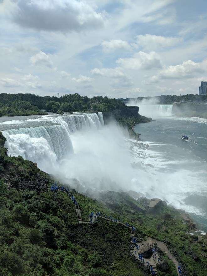
We flew a relatively short leg to the Niagara Falls airport, just north of Buffalo, NY. With some clouds fairly close to the ground, our flight required some navigation between the restricted area over the falls as well as the clouds before we crossed the border and landed.
Crossing the border in the US was just slightly more difficult. We landed, and were approached almost immediately by an official (was this customs? border patrol? I really wasn’t clear). In addition to looking at us and our passports, he also scanned our airplane with a Geiger counter. I really have no idea why it’s likely that a family of four people on a small single-engine plane would be suspected of carrying radioactive material, but so be it. We passed the test.
Since we were in Niagara, we borrowed a crew car from the FBO and spent a couple of hours eating lunch and visiting the falls, which the kids enjoyed. I’d never been on the US side of the falls and found it actually a bit more interesting to visit even if the view from the Canadian side is more magnificent.
Second Leg, Day 1: KIAG to KCGF
The remnant of the day was spent on the flight following the shore of Lake Erie towards Cleveland.

We’d decided to land at the Cuyahoga County airport about a half hour outside of Cleveland, where we’d arranged a rental car for the day since we were going to visit one of Linda’s cousins who lives there. The flight — apart from fuel pressure beeping — was only eventful in us tracking a narrow 10 mile zone between the southern shore of the lake and the northern edge of a thick bank of clouds that hung out a consistent distance from the shore for most of the way. In addition we kept having to be turned left and right to avoid low-flying traffic until I gave up and climbed a bit higher.
I’d looked up Diamond authorized service shops before we left. There wasn’t one in Cleveland, but there was one in Youngstown, about a 20 minute flight southeast. I’d move the plane there the following day and try to get my problem resolved — I’d called up the shop and gave them enough information to get them to order the part I needed, and knew it’d arrive when I’d be flying in.

Reposition: KCFG to KYNG
The following morning the shop in Youngstown gave me a call — my part has arrived. I Ubered to the airport while Linda and the kids went to Cleveland to visit the zoo and whatever other attractions they found. I, meanwhile, flew over to Youngstown — which as I found out was a TRSA, thus making it the second TRSA I’d ever visited (the first being Palm Springs). The airport was also notable for being a place where military large aircraft training seemed to be happening — after landing, I witnessed a four-engine turboprop perform a touch-and-go followed by a tight pattern and more of the same.
Luck was not on my side. The shop ordered the wrong part. It seems like the shop looked in the online parts manual for the DA40, which happily lists parts for the steam gauge version of my plane with a Vision Systems engine monitor. And Vision Systems gauges and probes. But since my plane has a G1000, the right document to use is the G1000 maintenance / parts manual for the DA40. Somehow the shop didn’t realize this, and thus ordered this expensive but incorrect part.
After realizing the problem, we got to work on other things they could do. For example, on some advice I’d received, they’d swapped the fuel pressure and oil pressure transducers — it was the same part number and they’re swappable after cleaning. I did a run-up and even flew a test pattern, which showed everything was fine. But the maintenance supervisor was really uncomfortable with me flying a long distance with a potentially unreliable oil pressure gauge, and I agreed. So we decided to order the correct part and have it installed when it arrived the following day.
The following day, though, was a Saturday. The shop arranged for me to borrow their crew car, and they would have some maintenance folks come in and wait for the part, at which point they’d call me and I’d get back with the family to them. I grabbed the car, drove back up to the Cleveland area to pick up my family, and then we all drove to Pittsburgh for the night to visit yet another city (Youngstown is about half-way between Pittsburgh and Cleveland).

The following morning, having checked out of our hotel in Pittsburgh, we started a drive back up to Youngstown. About 10 minutes before we got there, I got a call from the shop that not only was the part not there, but the carrier said that it was delayed due to some technical issue and wouldn’t arrive till Monday.
Linda and I had been thinking about how we’d get the family back in time (Mateo had a class he needed to arrive for on Sunday), and had decided that we’d fly as far West as we could and then she and the kids would just catch a commercial flight back. So, we started executing this plan — we found a flight the following morning from Cincinnati, booked an overnight hotel, and I started driving the 4 hours from Youngstown to Cincinnati in that same borrowed crew car.
We overnighted in Cincinnati, Linda and the kids flew out early morning on Sunday, and I drove back half-way to Columbus, OH, so as to overnight there and have less of a drive on Monday.
Third leg, Day 2: KYNG to KHUF
On Monday, I drove towards Youngstown and the folks at the shop called me to tell that the part arrived and they swapped it successfully. They’d also swapped some scat hoses for me, which had apparently begun to get worn.
Since I was without family in the plane now, certain things were easier. Fuel could be topped off; I could play whatever music I wanted; I could fly longer legs. On the other hand, the flight was much more boring and I got more tired of sitting in the plane than before. With XM Radio in the plane, I listened to a lot of 80s and 90s music in the following several hours of flight.
Initially I was going to fly to KAID, an airport outside of Indianapolis. But about an hour into the flight it seemed that the weather was good, and there was plenty of fuel, so I decided to continue to KHUF in Terra Haute, Indiana. This required a change to my flight plan, and so I told ATC of the change and asked if I needed to inform flight service of it as well — but the controller said that this was not necessary since he could make a change on their end. I landed at KHUF for refueling, and had the tower tell me that I was overdue and that they were closing my flight plan for me; a message on my phone said that search and rescue was starting. I called up flight service to make sure everything was good, and they told me that ATC hadn’t updated anything in the system. Lesson learned — call up flight service and change the plan with them.
Another lesson learned: how to pronounce Terre Haute. It’s not “Ter Ot”, or “Terr Hot” but rather “Ter-rey Hoht”.
Fourth Leg, Day 2: KHUF to KSGF
 The next flight of the day took me to Springfield, Missouri. By the time of this flight, some weather crossing the middle of the country from west to east had started to come pretty close to me — I was flying a bit north of a series of thunderstorms and precipitation, and south of a couple of scattered ones. Some particularly mean-looking storms were forming literally as I flew past them. In fact, I almost had to deviate from my destination since there was some lightning reported near it — but by the time I’d arrived nearby, the storm had moved on further east. I landed in some bumps, and even saw a bolt of lightning in the distance over downtown Springfield as I was on short final. With this weather around me, there wasn’t much of a thought on continuing on that day. I booked a hotel room (thanks to a great FBO discount), and spent the night in Springfield.
Fifth Leg, Day 3: KSGF to KLAW

The morning brought mostly clear weather to the South, and some precipitation nastiness to the west of me. I had to plan for a flight that wasn’t directly to the west, but instead took me south around the weather. I flew about fifteen miles south of the weather, at its altitude, and decided to head on to Lawton, Oklahoma.
Lawton is a small town not too far from the Oklahoma/Texas border. It seems to share its airspace with Fort Sill, an Army base, and there is a bunch of restricted airspace just north of the town. A quick stop for fuel, iPad recharging, and cookies, and I took off again.
Sixth Leg, Day 3: KLAW to KSAF
 A note about cookies. The FBO had a box of them and welcomed me to have some. Since I was hungry I ate one, and grabbed two to go. On this three hour leg to Santa Fe, I ate one cookie when I had two hours to go, and another with one hour. Yum!
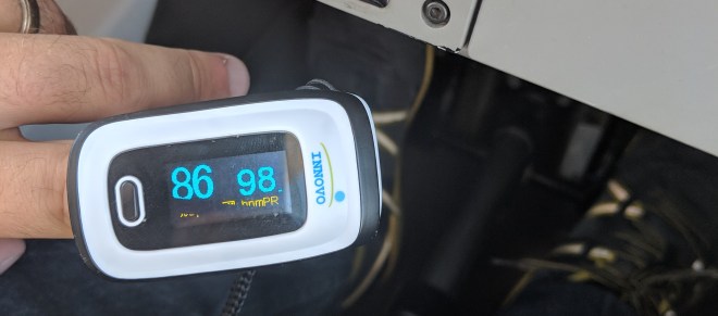
Santa Fe was a treat for me, since I was going to spend the evening with close family friends from when I was a kid. The flight itself was fine, but because of clouds at 10,500 I ended up climbing to 12,500. Being at that level made me nervous about oxygen levels and so I kept setting myself thirty minute timers, and also kept checking my saturation with a pulse oximeter every 5 to 10 minutes. There was some weather not too far from Santa Fe, so landing was hot, windy, and bumpy. Given that Santa Fe has three runways, odd winds seem to be a common thing there.
Seventh Leg, Day 4: KSAF to KHII
After a nice day and night in Santa Fe, I got an early morning start to avoid the thunderstorms that inevitably develop over NM and AZ in the afternoons.
 I had initially filed to Sedona, but the flying was fine and fuel was sufficient, and so I changed my destination to Lake Havasu instead. This time both calling up ATC and Flight Service. Fun fact: two different FSS controllers can hear you sometimes, and can’t hear each other, which makes for some fun conversations as you try to let one know that the other has handled your request… “Um, I’m able to hear a female voice and a male voice. I’m having trouble hearing the female voice but the male voice has helped me already, thanks!”
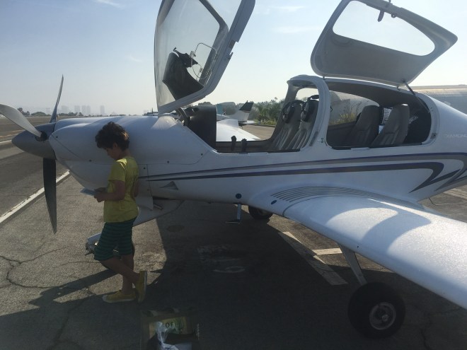
 Lake Havasu is untowered. ATC let me go about ten miles out and I landed in the hot desert with a few other planes in the area.
Eight Leg, Day 4: KHII to KCRQ
After a quick refueling, and a nice ice slushie from Desert Skies FBO, I continued on towards Palomar Airport — Linda had taken the kids to Legoland for a couple of days, and it was my responsibility to take over for her and to get the kids back to Santa Monica the following day.

This was a quick 90 minute flight. I stayed high above the hills east of Palomar and attempted to intercept the RNAV approach, but the controller had to vector me away due to traffic. Parking was at Magellan, where I’d been before.
Final Leg: KCRQ to KSMO
The following day, after a bit of fun at Legoland with the kids, we headed home via the coast. Due to weight and balance issues, Mateo flew in the front.
As familiar I am with this route, it was surprisingly challenging due to California’s wildfires delivering a ton of the smoke right at the altitude I was flying and right over the LA basin. I didn’t realize it at the time but the smoke was in a thin layer right at 4,500ft, which was the altitude I chose to let me fly right into the Special Flight Rules Area over LAX.
The smoke was so thick that my visibility was down to maybe 3 or 4 miles. Whenever ATC vectored me away from the shore for traffic, I almost wanted to tell them Unable, and the thought of climbing and deviating somewhere not smoky was on my mind.
But visibility improved as I flew. ATC was helpful in pointing out traffic, and by the time I got to the SFRA I could see closer to 8 miles and continued on through the corridor. As soon as I descended out of the corridor for landing visibility increased to at least 20 miles. We landed, and finished my long long cross country trip.
What are some things I’d learned?
For flying, there were some good choices that I’d made. I brought two and a half quarts of oil, and that was just enough to refill the gradual use during the trip. I bought a Stratux at the last moment and that was a great addition to my situational awareness arsenal, especially for weather. I got decent headsets for the kids, and that helped them sleep and watch movies.
On the other hand, the tiedowns I got went unused since I spent all my time at FBOs with full service and their own ropes when necessary.
While I knew about weather theoretically, it was quite a different thing to experience weather in person. There is fairly little diversity in SoCal weather, so having to deal first hand with the turbulence over Rockies, and the pop up thunderclouds over the plains, and the humidity and rain further east… I think this was a much better way of learning what weather actually behaves like.
Overall, it was also great to learn to adapt to unusual and unknown airports, and make plans dynamically based on circumstances. This made the trip feel more “in the moment” rather than master-planned and added to its sense of adventure. So the restrictions imposed by weather and terrain in a way served to enforce making the trip more enjoyable.
It was also good to fly longer distances. I now no longer really think of a 3 hour flight as something long and scary — I respect the planning required, and don’t want to make light of the risks or become complacent, but it’s good to know that long trips are what the airplane was made for. I now look at flying up to, say, Oregon, as a fairly reasonable thing to do. And that’s exciting.

